

Arbors of time
25 August 2022
Share


 We have been having some interesting discussions with ArborMeta, an enviro-tech company that uses LiDAR technologies to pioneer modern forest measurement techniques. The technology they are using sets a new standard for carbon stock quantification. Up to this point, forest science has relied on the use of tape measures, subjective metric estimates, and poorly calibrated satellite data to deliver crude analyses of forest structures and biomass across the globe. However, these processes fall short of the quality needed for high-integrity carbon offsetting.
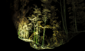
By employing top of the range terrestrial LiDAR scanning instruments, ArborMeta can capture point-cloud ‘digital twin’ representations of tree and forest, across all forest types. This data allows for a comprehensive quantitative analysis at both the tree and plot level, capturing physical metrics like tree woody volume, diameter at breast height (DBH), height, and canopy area with objective accuracy. This allows us to measure woody biomass and carbon stock with unprecedented confidence and efficiency.
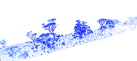
By using both terrestrial and aerial LiDAR scanning, ArborMeta can use ground-truth terrestrial plots to calibrate aerial LiDAR data, unlocking the potential of broad-scale direct measurement by eliminating the error normally involved in such processes. The digital nature of LiDAR ensures all data gathered is secure, readily auditable, and transparent.