

Birds Eye View: Exploring how Drone technology and remote sensing are shaping the future for environmental insights
01 May 2025
Share


 Drones are enhancing the way we work, offering new perspectives and capabilities across industries—and we’ve only just begun to unlock their full potential.
A big Thank You to Amy Steiger, GISP-AP from Stantec, for leading our last Webinar “Mapping and monitoring the inaccessible: How drone technology and remote sensing are shaping the future for environmental insights”
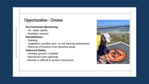
Amy shared her expertise in remote sensing technologies, highlighting how drones and satellites are transforming environmental monitoring by providing accurate, consistent, and wide-reaching data.
As the Geospatial Discipline Lead for Stantec (Australia & New Zealand) and Chief Remote Pilot, Amy brings over 18 years of geospatial experience. Since 2013, she has played a pivotal role in advancing drone integration at Stantec, all while maintaining high standards of safety and quality.
Her presentation featured case studies that not only demonstrated the practical benefits of drone technology but also underscored the ongoing opportunities for innovation and growth in this space.
Missed the session? You can watch the full recording on our website.
Visit our Webinar Library