

Simulating catchments using digital twins
25 March 2022
Share


On a related matter, HydroTerra has been working closely with our partners from The Mulloon Institute to better understand catchment rehydration processes.
One area being explored is using digital twins and modelling of catchment processes, particularly the capacity to simulate moisture movements and distributions across catchments.
Our current focus has revealed some impressive work. A collaboration between Australian ag-tech start-up Agronomeye, Microsoft, and Australia’s national science agency CSIRO has demonstrated the capability to visualise and simulate catchment moisture distribution at catchment scale using digital twins. The new AgTwin platform brings together disparate spatial data sets and real-time sensor data, presenting this in a simple way to interpret. The goal is to assist farmers by creating high-resolution maps of farming properties and predict the flow of water across every hectare of the farm.
At CSIRO’s Boorowa Agricultural Research Station, the AgTwin platform has been used to present a rich collection of data. It brings together multiple agricultural data sets including data sourced from in-soil and on-farm sensors, satellite imagery and drones as well as Bureau of Meteorology data, which can be analysed using artificial intelligence (AI) and machine learning. For further information visit agronomeye.com.au.
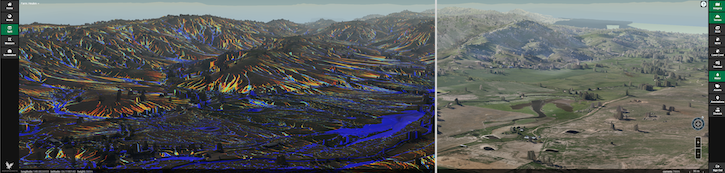
Picture: Courtesy of Agronomeye