

Challenges of monitoring at scale
20 October 2022
Share


 One of the challenges of environmental monitoring is getting metrics at a scale that meets the needs of the operation. This is particularly true for farming and catchment management. Sensors, such as Sentek capacitance probes, provide a measurement radius of approximately 14 cm around the probes for example. Extrapolating these readings to a paddock or catchment scale can be challenging. As part of a recent project, HydroTerra investigated some methods for scaling point measurements for catchment studies. In this newsletter we provide some information on two interesting approaches, one scaling point measurements using combinations with Normalised Differentiation Vegetation Index (NDVI) imagery, the second a measurement technology developed by CSIRO known as CosmOz that can measure soil moisture at the scale of hectares.
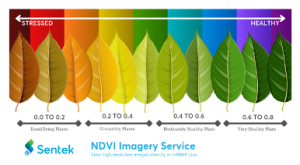
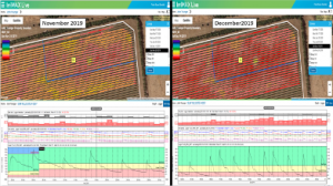 Point measurements such as those produced from capacitance probes are useful for understanding plant water use processes, for example continuous time series data and data analytics allows estimates of parameters such as: Daily crop water use; daily evaporative and drainage loss from the soil profile; the depth and distribution of the root zone; fertilizer impacts and salinity trends; saturation points; the onset of stress and the recording of implemented irrigation strategies. However, in many applications having a spatial context of plant performance combined with this process data provides a really powerful insight into the success of a particular management strategy. Some companies are using satellite data to achieve this spatial context. For example, Sentek Technologies now offers an investigative tool as part of their IrriMAX Live software to present both a Google Map View of the selected property where water gauges and soil status are available but also combine this with NDVI satellite images taken throughout the season. NDVI measures the state of plant health based on how the plant reflects light at certain frequencies. This provides a spatial data set with a time series context.
Our next article provides a more detailed look into the fascinating CosmOz project.
For more information on soil moisture monitoring solutions from Sentek, check out the article later in this newsletter.